Which satellites does Amazon Leo have in orbit right now? How has the ISS’s altitude changed over the past month? How close did two satellites in the HawkEye 360 constellation get yesterday?
Until now, answering questions like these meant finding the right tool, pulling TLEs and often writing a script. With Satcat for ChatGPT, you can just ask.
Satcat for ChatGPT brings the Satcat satellite catalog directly into your ChatGPT conversations. Search for satellites, chart their orbits, compare them side by side and see them on an interactive 3D globe, all in plain language and without leaving the chat.
Space Data, One Question Away
Kayhan Space built Satcat to make spaceflight intelligence available to everyone, from satellite operators to space enthusiasts. Earlier this year, Satcat Terminal added an AI agent that lets anyone explore orbital data without an astrodynamics background. Satcat for ChatGPT takes the next step: it brings that intelligence into a tool millions of people already use every day.
Connect your Satcat account once, and ChatGPT can draw on the same catalog that powers Satcat. Every answer is based on real catalog data, not estimates or guesswork.
Find Any Satellite
Search the catalog by name, NORAD ID, international designator, owner, country, mission or orbital parameters. Ask for a single spacecraft or a whole fleet, then pull its latest or historical TLEs, or compare several satellites side by side.
See Orbits on an Interactive 3D Globe
Show individual satellites or filtered groups on an interactive 3D globe, right inside the chat. Rotate, zoom and explore how a constellation is laid out, without opening another app.
Try it: “Show me AST SpaceMobile satellites on the globe.”
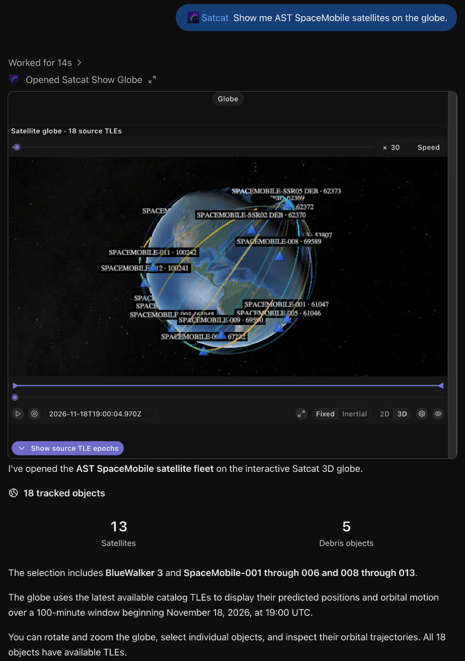
Chart How Orbits Change Over Time
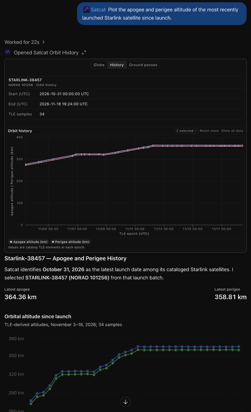
Plot orbital-element history to see how a satellite’s apogee, perigee, inclination and other parameters have evolved. Spot orbit raising, decay or station-keeping at a glance.
Try it: “Plot the apogee and perigee altitude of the most recently launched Starlink satellite since launch.”
Measure the Distance Between Satellites
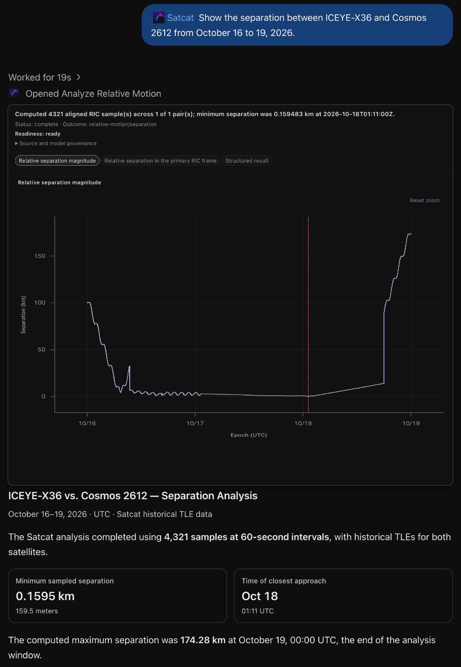
Chart the separation between any two satellites, broken down into radial, in-track and cross-track (RIC) components. It’s a fast way to understand formation flying, proximity operations or how closely two neighbors share an orbit.
“Show the separation between ICEYE-X36 and Cosmos 2612 from October 16 to 19, 2026.”
Keep an Eye on GEO and Orbital Neighbors
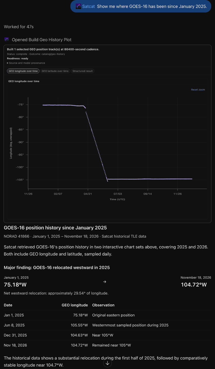
Track a GEO satellite’s longitude history and see who its neighbors are. You can also find satellites in similar or shared orbital planes, which is useful for understanding crowding and coordination needs.
Try it: “Show me where GOES-16 has been since January 2025.”
Know When a Satellite Passes Overhead
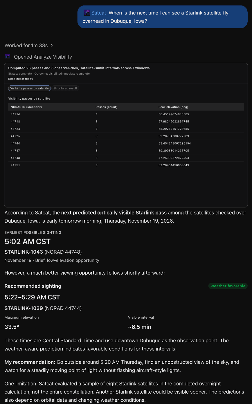
Give Satcat one or more locations, and it predicts geometric ground passes above an elevation mask you choose. It can also find the windows when your site is dark while the satellite is sunlit, the conditions for spotting it, with optional weather filtering.
Try it: “When is the next time I can see a Starlink satellite fly overhead in Dubuque, Iowa?”
Built for Everyone
Whether you’re a satellite operator or just learning about satellites, Satcat for ChatGPT meets you where you are.
- Satellite operators: Check on your fleet and your neighbors between screenings, without opening another dashboard.
- Space situational awareness analysts: Go from a hunch to a chart in seconds, using RIC separation, GEO neighbor tracking and orbit-plane discovery.
- Researchers: Pull historical TLEs and orbital-element trends for analyses, reports and briefings.
- Students and educators: Learn how orbits work by asking questions and seeing the answers on a 3D globe.
- Everyday users: Look up satellites and see where they are in real time, when they were launched, who owns them and what we know about them.
Good to Know
Satcat for ChatGPT is built for exploration and analysis, and it’s upfront about its limits:
- Results are predictions sampled from catalog TLEs. Every response reports truncated selections, stale TLEs and unavailable values.
- Ground passes are geometric line-of-sight predictions. Visibility analysis does not assess imaging, SAR or RF access.
- Catalog classifications do not establish a satellite’s nationality or military status.
- You only see data your Satcat account can access.
For conjunction screening, collision-risk assessment and maneuver planning, use the full Satcat for Operations platform.
Get Started with Satcat in ChatGPT
- Find Satcat in the ChatGPT plugin directory and select Install plugin.
- When ChatGPT asks you to connect, sign in to Satcat and approve the authorization request. This lets ChatGPT sign in with your Satcat account and see your email address. Don’t have an account? Create one for free at satcat.com.
- Ask your first question. Try one of the examples above, or ask about any satellite you’re curious about.
From tracking a single spacecraft to mapping an entire constellation, there’s always something new to explore. Give Satcat for ChatGPT a try, and let us know what you discover!
Latest blog posts
Introducing Synthetic Covariance: Uncertainty and Actionability for the SP Catalog
Satcat Operations Pro now generates Synthetic Covariance for the SP catalog, enabling true Pc on almost every conjunction instead of relying on miss distance alone.
Introducing: Satcat for ChatGPT
Ask ChatGPT about any satellite. Satcat for ChatGPT lets you search the catalog, chart orbits and see satellites on a 3D globe, all in plain language.

Tracking the Tracker: Is Russia's LUCH (OLYMP) Approaching the End of Its Mission?
Launched in 2014, Russia’s Luch (OLYMP) became one of the most closely watched satellites in geostationary orbit for its deliberate proximity operations with commercial and mili...